The Tongariro Crossing is known as New Zealand’s greatest one day walk. My brother Joel did it a couple of years ago and he said it was ‘the best walk he’d ever done’ – this from someone who isn’t best known for his love of walking! After our paddle up the Whanganui River, David was keen to do this walk as was not far away. However, rain was forecast and our River guide advised us that if it’s raining then there’s not much point doing the walk, so we travelled up to do the Glow worm caves and Hobbiton instead. Privately I was relieved as I was knackered! However, as soon as the weather perked up, David persuaded me to travel 150 kilometres back down South to do the walk. Arriving in the area the evening before, we found both the nearest campsites full. It was beginning to get dark and for the first time since we arrived in New Zealand, I feared that we weren’t going to find a place to stay. In the end we found a motel with some space for campervans in the car park. Despite the late hour, we managed to arrange a shuttle bus to take us to the start of the walk, departing at a very respectable 8.30 a.m. It would pick us up from the end of the walk at 4.30 p.m.
The next day the roads were busy with people trying to get to the start of the trail. One of the routes was closed due to a serious accident, which meant that shuttle buses were being diverted from the two nearest campsites which we’d tried to get into the night before. Once we were on the trail, we found that there were plenty of walkers like us who had delayed doing the walk until the weather perked up. And today the weather was perfect. We started out in hats and fleeces but were soon shedding layers, ending up in T-shirts and shorts.
The Tongariro Crossing has recently been rebranded as The Tongariro Alpine Crossing to better reflect the nature of the terrain. The trail climbs to over 1800 metres high, is very exposed and conditions can change very quickly. We were prepared for most conditions with a backpack full of food, snacks, water and a variety of different clothes. Our shuttle driver, a Maori who knows the walk well, suggested that walking poles were a good idea and offered to lend us some. At first the poles were an encumbrance but later, we were very glad we accepted his offer.
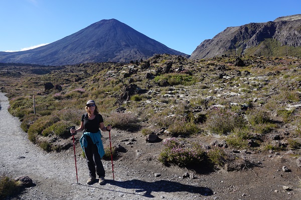
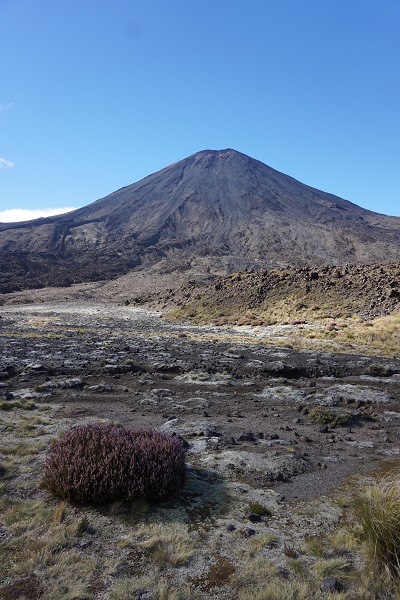
The walk starts at the Mangatepopo Road in the National Park, and climbs the Valley to cross the saddle between Mount Tongariro and Mount Ngauruhoe (Mount Doom from the Lord of the Rings films). We could see steam pouring out of Mount Tongariro. The entire area is a Volcanic hazard zone and warnings told us what to do if there was an eruption – however, our driver reassured us that although there had been some recent eruptions, technology could predict when this was likely to happen – and nothing was predicted for today!
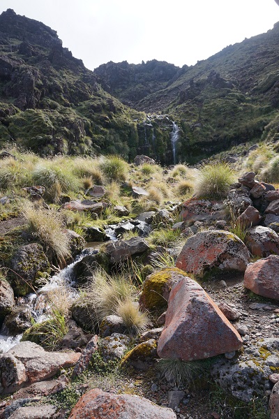
The first leg from Mangatepopo Road to Soda Springs was easy, with well maintained board walks to walk on and a rather gentle ascent. The scenery was awe inspiring. We were surrounded by massive peaks and walking in an environment which looked like a lunar landscape. There were a few hardy plants, including some white litchen which looked like snow. At Soda Springs (a little waterfall) we found some large rocks to perch on for our first ‘refreshment’ stop.
After the falls, we started to climb into the mountains. The path was quite demanding with run after run of wooden steps known as the Devil’s staircase. As I climbed up into the harsh volcanic wastes which were overshadowed by Mount Ngauruhoe, I could well imagine I was Bilbo climbing up towards Mordor – apparently it was filmed here. However, I said to David that after doing the Escarpment Trail at Paekakariki, I found it quite tame. Of course it would be a different picture if there was snow on the ground and the winds were whipping up.
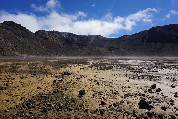
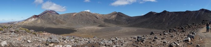
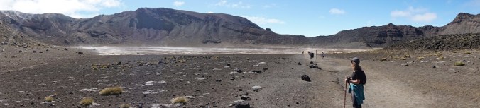
The reward for all this climbing came at last as we reached the top. We were looking down into a volcanic crater (South Crater) at the heart of which was a boiling, sulphurous, yellow lake. The crater itself was a welcome break after our ascent as it was as flat as an iceskating rink, but the landscape was eerily inhospitable.
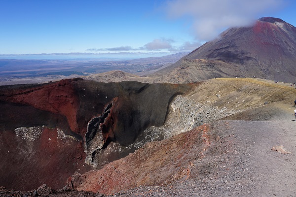
After South Crater, we started to climb again. The path was no longer boarded. The volcanic rock was covered with stones and scree which was hard to get a purchase on. In places it was quite hair raising as we were on a ridge, looking down over the steep drops on either side. My comment about this being ‘easier than the Escarpment trail’ now seemed quite hollow. I was thankful for the climbing poles. Finally we reached the top and were rewarded with a spectacular view of the Red Crater below us. The Red Crater was formed about three thousand years ago. Within the red crater was a lava dyke. This spectacular feature formed when the crater erupted. The lava flowed back into the crater before it had time to cool, leaving behind a tube which was then exposed by later eruptions.
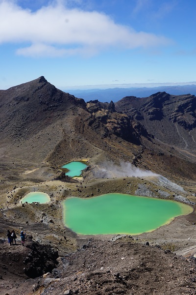
After staring at the Red Crater, we followed the hoards of walkers who were climbing even higher up the ridge. On reaching the top of the ridge, I was so blown away by the view, I was stunned into silence. Doesn’t happen very often, folks, as David will confirm! Below us were a collection of brightly coloured pools – three dazzling Emerald Lakes and one large Blue Lake. After taking some photographs, we set off eagerly towards the lakes. However, our eagerness soon gave way to alarm as we realised how dangerous this part of the walk was. The ridge was very narrow and steep and the ground was covered in volcanic dust and loose scree. There were so many walkers careering down the slope at the same time, there wasn’t much room for error. Once again, the walking poles were invaluable – but they can’t stop you falling backwards as David discovered when he fell and landed hard on his bottom.
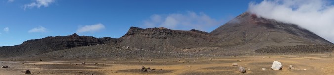
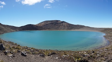
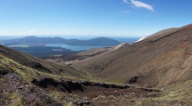
Once we were down the slope, we climbed again briefly to curve around the rim of Blue lake and onto a flat plain. Time for a quick toilet break before we commenced the second half of the walk. After all the excitement and challenges of the first half of the walk, the second half felt quite tame: tthe path zigzagged slowly down the hill for the best part of three hours. However, the sun was shining and we had yet another inspiring outlook to enjoy: to our right, Mount Pihanga, a volcanic peak, was gently smoking. Ahead was Lake Rotoaira and beyond that the massive Lake Taupo. Taking time to look around, the path was surrounded by pretty alpine flowers and plants. We passed a sign to Ketetahi hot springs – sadly, not open to the public. After a quick stop on the steps of the Ketetahi Hut to eat the last of our food, we bolted down the hill. Time was marching on, and we were anxious not to miss our shuttle bus.
The track dropped steeply to the Mangatetipua Stream and we were treated to a pretty wooded walk across bridges. By this time, my shins were killing me and I had to force myself to keep moving. Signs warned us not to linger as we entered an area affected by ‘lahars’ – volcanic flows made up of lavae, water and debris which can be dangerous and destructive. A final sting in the tail!
Despite this, we made it to the Ketetahi Car Park with twenty minutes to spare. By the time we climbed on board the shuttle bus, my legs had cramped up. Our driver took my walking poles off me, offered me congratulations and pushed a cold beer into my hands. Clearly a man who knows what it takes to walk the Tongariro Crossing!